Figure2: This picture was taken from Alzamel for Realstate
Figure3: This picture was taken from www.henninglarsen.com
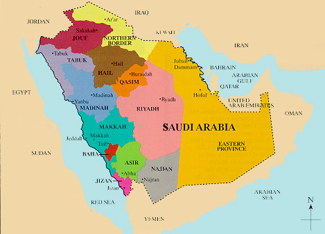
Province |
Capital |
Governor |
|
|
||
| Riyadh | Riyadh | The capital and largest city of Saudi Arabia.
It is also the capital of Riyadh Province. Ref. Wikipedia |
|
|
||
| Makkah | Makkah | Is the most populous region.
the holiest city in Islam, and
its largest city is Jeddah, which is also Saudi Arabia's main port city. Ref. Wikipedia |
|
|
||
| Madinah | Madinah | Is also a city in the Hejaz, and the capital
of the Al Madinah Region of Saudi Arabia. The city contains the Prophet's Mosque, which is the burial place of the Islamic prophet Muhammad. Ref. Wikipedia |
|
|
||
| Eastern | Dammam . | Is the largest province of Saudi Arabia.
It is home to most of Saudi Arabia's oil production.
The region is also home of the City of Jubail, which
hosts the Jubail Industrial City, a global hub for
chemical industries. Ref. Wikipedia |
|
|
||
| Asir | Abha | Is situated on a high plateau that receives
more rainfall than the rest of the country and
contains the country's highest peaks Ref. Wikipedia |
|
|
||
| Al-Baha | Al-Baha | Is the name of the province as well the main city.
. The region is formed of mountains, plains, hills, valleys and desert stretches.
The al- Baḥah region includes al-Baḥah city, Almikhwah and Baljorashi.
Baljorashi has a famous traditional market known as sooqe as-sabt, which translates
to English as "Saturday market". The Baljorashi market is very old and its exact age is unknown. Ref. Wikipedia |
|
|
||
| Tabuk | Tabuk | Tabuk is close to the Jordan–Saudi Arabia border.
It houses the largest air force base in Saudi Arabia.
Desertous continental weather with hot summers and mild
winters. Ref. Wikipedia |
|
|
||
| Qassim | Buraidah | Al-Qassim is the richest region per capita in Saudi Arabia.
It is the seventh most populated region in the country after
Jizan and the fifth most densely populated. It has more than
400 cities, towns, villages, and Bedouin settlements, ten of
which are recognized as governorates. Ref. Wikipedia |
|
|
||
| Hail | Hail | Is located in the north of the country. It has an area of 103,887 km² and a population of 527,033 (2004) census). Its capital is Haʾil. It is subdivided into four governorates Ref. Wikipedia |
|
|
||
| Al-Jouf | Sakakah | The region is home to a few historical sites such as Az-Za'bel, Umar ibn Al-Khattaab Mosque, the Kaf Village and the Qadeer Palace, which is known for stone inscriptions. Ref. Wikipedia |
|
|
||
| Northern Borders | Ar'ar | Is located in the north of the country, bordering Iraq and Jordan. It has an area of 111,797 km² and a population of 320,524 at the 2010 census (preliminary result).
Ref. Wikipedia |
|
|
||
| Jizan | Jizan | is the second smallest (smallest region is Al Bahah) region of Saudi Arabia.
The region includes over 100 islands in the Red Sea. Jazan is the poorest area in Saudi Arabia. 34% of Saudi families in Jazan live in poverty.
Ref. Wikipedia |
|
|
||
| Najran | Najran | Is a city in southwestern Saudi Arabia near the border with Yemen.
Najran was the Yemeni centre of cloth making and originally, the kiswah or the cloth of the Ka'aba was made there (the clothing of the Kaba first started by the Yemeni kings of Saba). There used to be a Jewish community at Najran, renowned for the garments they manufactured. According to Yemenite Jewish tradition, the Jews of Najran traced their origin to the Ten Tribes. Najran was also an important stopping place on the Incense Route. Ref. Wikipedia |